
|
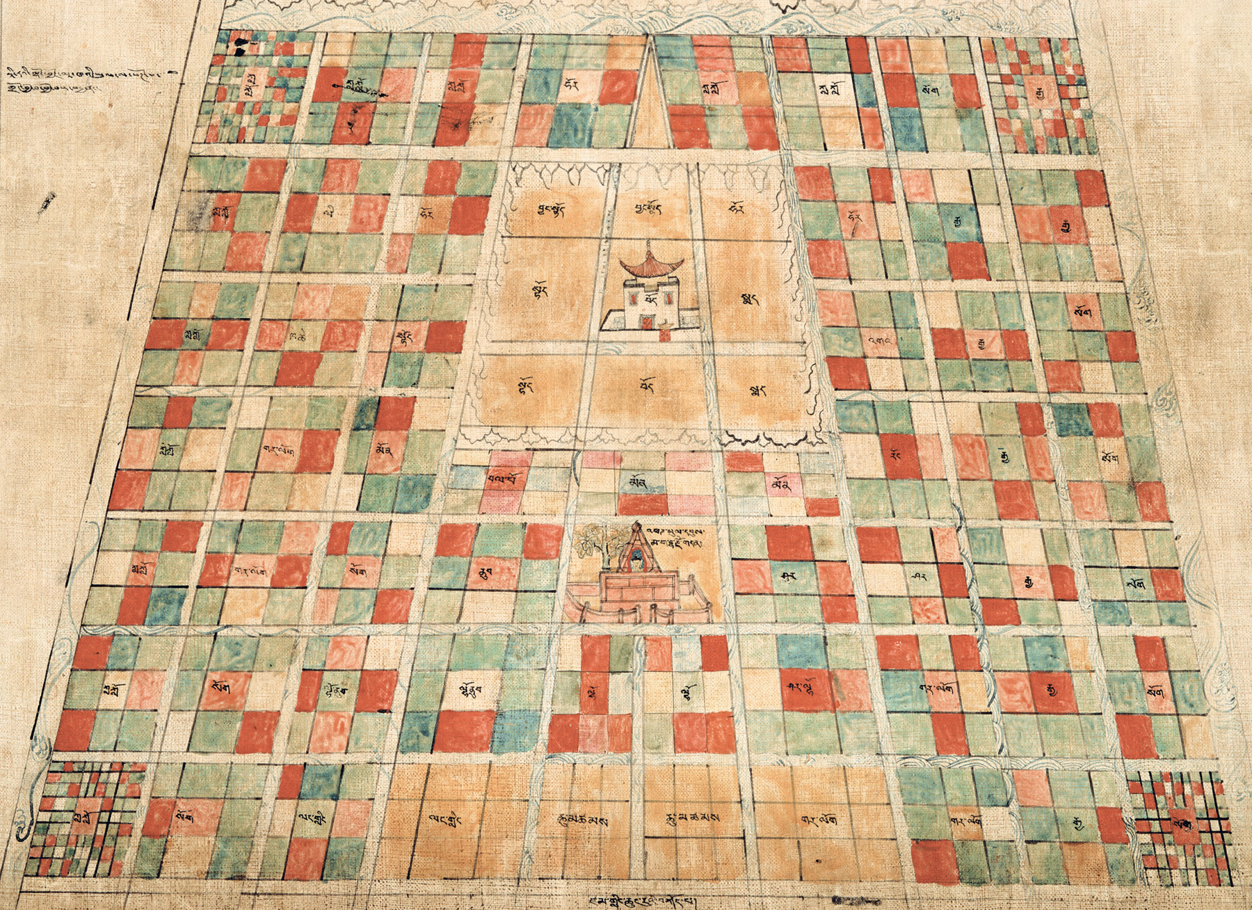
| The second painting, of Jambudvīpa. |
Outer Kālacakra
Jambudvīpa and Sambhala
Previous Page – Next Page
This second painting depicts the southern continent of Jambudvīpa, and many locations within it are clearly labelled. The Kālacakra Tantra and its commentary, the Vimalaprabhā, describe a distinction between two areas. In its commentary to the verse predicting the first Kalkī king, Yaśas, the Vimalaprabhā states (the original words of the tantra are italicized):"Regarding, After this year, six hundred years, there will arise in Sambhala the appearance of the lord of men, Yaśas, this year is referring to the year when the Tathāgata taught the Dharma (of Kālacakra). Six hundred years after that year, in Sambhala, north of the River Śītā, there will arise, Yaśas, as it says in the text, Mañjuśrī, the great Yaśas, his appearance, meaning that he will take a nirmaṇakāya body.
"Then after nāga hundred years, means that nāga, eight, hundred years after the nirvāṇa of Yaśas, for certain, meaning without doubt in the land of Mecca, the barbarian teachings will be established. South of the River Śītā, in the land of Mecca with ten million villages, the demonic teachings of the barbarian Tajiks will be established."
Regarding the Kālacakra calendar, the Vimalaprabhā makes the point that the Hindu calendars will become corrupt in the area south of the River Śītā, due to their lack of appreciation of precession, described as an Islamic concept (ie. something the Islamic astronomers understood, and the Hindu ones did not). However, north of the river, the Buddhists methods of astronomy will not be corrupted.
Some of these locations are described in the painting. The writing near the top on the right-hand side states: "The 960 million villages north of the Śīta". (The Tibetan text actually has "Sīta". In this word and Sambhala, Tibetan texts often have "Ś"/"Sh" where the Sanskrit texts have "S", or vice-versa. I use the original Sanskrit spellings here.) The writing on the left-hand side, near the half-way point, states: "South of the Sīta, adorned with the 10 million villages of Mecca and so forth." Clearly, just above the level of this writing, running horizontally across the painting, is the River Śīta. Right in the middle, very near the top, is the phrase gangs ldan, Himavat. These are the mountains said to be north of Kailash, and at the extreme north of our continent. These are clearly the mountain chain depicted along the top edge of the painting.

|
| Close up of Sambhala. The writing at the top is not quite legible, but includes the word "Kailash". The words at the bottom state: "On top of Kailash, Sambhala. |
In the centre, just above the river, is the circular form of Sambhala. The text seems to suggest here that Sambhala is on top of Mt. Kailash. The area below, to the south of, the river has many labels. This are listed below and labelled in the picture below.
|
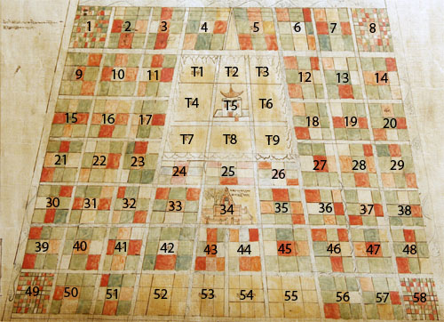
| Key to the area south of the River Śītā |
|
1,2,3. Muslims, kla klo
4. Turkestan, hor
5,6. Muslims, kla klo
7. Mongolia, sog
8. China, rgya
9. Muslims, kla klo
10. Khotan, li
11,12. Turkestan, hor
13,14. China, rgya
15. Muslims, kla klo
16. Kashmir, kha che
17. Western Tibet, stod
18. Ga – a region in eastern Tibet, 'ga'
19. China, rgya
20. Mongolia, sog
21. Muslims, kla klo
22. Gar-log, a border tribe, gar log
23. Mon – mountain region, near western(?) Nepal, mon
24. Nepal (Kathmandu valley), bal po
25,26. Mon – mountain region, near eastern Nepal, mon
27. Sikkim, Bhutan area, rong
28. China, rgya
29. Mongolia, sog
30. Muslims, kla klo
31. Gar-log, a border tribe, gar log
32. Mongolia, sog
33. West(ern India), nub
34. Vajrāsana in Maghadha, rdo rje gdan
35,36. East(ern India), shar
37. China, rgya
38. Mongolia, sog
39. Muslims, kla klo
40. Mongolia sog
41,42. South-west(ern India), lho nub
43,44. South(ern India), lho
45. South-east(ern India), shar lho
46. Gar-log gar log
47. China, rgya
48. Mongolia, sog
49. Muslims, kla klo
50. Mongolia, sog
51,52. Sri Lanka, lang ling
53,54. The coast, chu mtshams
55,56. Gar-log gar log
57. China, rgya
58. Mongolia, sog
Tibetan region:
T1,T2. North-western Tibet, byang stod
T3. Turkestan, hor
T4. Western Tibet, stod
T5. Central Tibet, bod
T6. Eastern Tibet, smad
T7. Western Tibet, stod
T8. Central Tibet, bod
T9. Eastern Tibet, smad
Map of Sambhala.

|
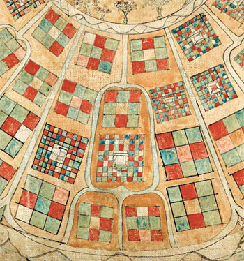
| The third painting, a map of Sambhala. |
The third in this series of paintings depicts Sambhala in more detail than is shown in the picture above. However, not many details are given in the original texts, and so not much detail can be expected in drawings such as these. Sambhala is said to be circular, surrounded by mountains, and shaped like an eight-petalled lotus, possibly symbolizing the channels of the heart centre. The capital, Kalāpa, is said to be in the centre, although some consider Kalāpa simply to be another name for Sambhala.
|
| Detail showing one of the eight sections of Sambhala. |
One praise to Sambhala by Dolpopa Sherab Gyaltsen (dol po pa shes rab rgyal mtshan) states that in the midst of snowy mountains, in the centre of an eight-petalled lotus is circular Kailash, on top of which is Kalāpa, with the king's palace in the midst of a sandalwood forest. This descriptions seems to identify Sambhala as Kalāpa, with the surrounding region in the shape of an eight-petalled lotus, with each petal divided into twelve regions, each with its own ruler, and containing 10 million vilages. This gives the total of 960 million villages mentioned in the Vimalaprabhā. In the image on the right, one of these eight regions has been highlighted.

|
| Detail of the capital of Sambhala, the city of Kalāpa. |
In the image on the left of Kalāpa, the king's palace is clearly seen in the centre. Another praise by Dolpopa states that the famous Kālacakra maṇḍala palace built by Sucandra in the Mālaya grove, lies to the south of the centre of Kālapa. This matches the first picture on this page, which has north at the top, but not the present one of Sambhala, unless one assumes that this one is drawn with east to the bottom, as is the case with maṇḍalas. In that case, the colours of the three-dimensional palace match. The maṇḍala palace is seen here left of centre, and the black/blue colour should be to the east, red to the south, and so forth. So, we can assume that this map is not drawn with north to the top, but west, in the normal style of a maṇḍala.
Dolpopa also states that east and west of the maṇḍala palace are ponds or lakes of sweet smelling, cooling water. This again matches the picture shown here. Dolpopa also mentions the presence of various birds, also seen in this picture.
Last updated 1 March 2010.
E. Henning.
Return to Home Page.